Showing posts with label hiking. Show all posts

Thursday, May 29, 2014

For the Benefit and Enjoyment of the People: Muir Woods National Monument

Muir Woods National Monument**
Impressive little strand of Coastal Redwood Trees-if only it weren't so crowded

Top Locations:
1. Cathedral Grove ***
2. Redwood Creek **
3. Bohemian Grove **
4. Kent Tree**

Time for Visiting: 1-2 hrs
Cost: $7
Best Season: Spring, Winter, weekdays
Bring: Camera, jacket
Difficulty: Flat+ : Main trails are flat, side trails can get strenuous

Scale: ***** Must Visit
          ****   Worth Detouring
          ***     If in the Area
          **       May be Worth
                     Visiting-Once
          *         Interest only


I never quite figured out Muir Woods-it is a nice enough grove of redwood trees, but the trees are fairly small and unimpressive, even compared to those in the Santa Cruz Mountains. The only thing I can think of to its advantage is that it is close to San Francisco, and that any tourists who can't make a trip up the Redwood Highway but still want to see redwood trees, can take a 20 minute trip across the Golden Gate Bridge to Muir Woods. Perhaps as a result of this, Muir Woods seems to be the single most popular park in the entire area, with crowds in the summer that rival those of Yosemite. Still, it's worth checking out, if you are in a time crunch in San Francisco and don't mind crowds.

Introduction
Muir Woods is a small, 2.5 km² protecting one of the last old-growth strands of Coastal Redwoods. The Coastal Redwood is a member of the Sequoia family, one of only three species left; the other two are the Giant Sequoia, the largest single organisms on Earth, and the the Dawn Redwood, thought to be extinct until rediscovered in China a few decades past. The Coastal Redwoods are among the tallest living things on Earth, the current record holder being the Hyperion in Redwood National Park at 115.61 meters, its location kept secret.  The trees here however, are only around 80m in height. Besides its impressive height, Redwoods have other interesting properties. They create their own microenvironment by causing cloud condensation at its canopy, can live up to 2000 years, and a remarkably fire resistant due to its low resin content.  Fallen trees may last for decades without rotting due to its high tannin content.

Still, the redwoods could not survive the progress of man. Originally numbering perhaps 8,000 km2 of old growth trees lining the Northern California coastline, by the 1900s most had been denuded for lumber in the wild quest for gold and building up the City of San Francisco (which until the 1900s had a habit of catching on fire and burning down). The grove later known as Muir Woods survived only because of its relatively isolated location in the middle of Mount Tamalpais.

Even then, the grove was eventually threatened. Progressive Republican Congressman William Kent and his wife noticed the threat, purchasing 2.5 km² of one of the last strands of Coastal Redwoods near San Francisco and donating it to the Federal government.  When President Theodore Roosevelt proclaimed the area a national monument, he offered to name it Kent Woods.  Kent however turned down the offer, suggesting instead it be used to honor the legendary naturalist John Muir.  Hence Muir Woods National Monument was created in 1908.

Trails
Muir Woods has basically one main trail that loops around Redwood Creek and the trees, with several secondary trails that split off and sharply ascend into Mount Tamalpais. 

1. Main Trail-Hillside Trail Loop
Distance: 3.9 km
Time: 1.5 hr
Difficulty: Moderate, Main Trail paved, flat; Fern Creek gradually sloping, Lost Trail strenuous.


The Main Trail of Muir Woods is flat, paved, and usually really, really crowded.  As soon as you pass the dramatic redwood gateway, a nice Visitor Center is on the right, selling some nice (if somewhat expensive, like everything in Marin) sandwiches and snacks. The trail quickly works its way among the Redwood Creek and the redwood trees and soon comes across the first of four bridges spanning the creek.

For first times visitors to the redwoods, this is a nice introduction.  The creek is picturesque, and between
December and early March, Coho Salmon, then Steelhead Salmon work their way upstream in the shallow waters.  You can rest on the bridges and watch the water (or people) flow by.

Further on, there are a Redwood Tree ring, showing the age of the tree from about 900 CE to 1930 when it fell.  Almost every redwood park seems to have one.


As you continue on, more and more redwoods are apparent. The trees are big (though not as big as they could be) and red.  In a few dozen steps, you will come across the Gifford Pinchot Tree, a nice redwood specimen named after the first Chief of the US Forest Service.

Even further on, you see the path first narrow, then widen into a small flatland.Surrounded on three sides by Mount Tamalpais, Muir Woods is dark, foggy and wet for much of the year, great conditions for redwoods to grow. The fog hangs here most of the morning, only evaporating completely by early afternoon.


If you look closely, you can sometimes see the ubiquitous banana slug, the second largest slug in the world, growing up to 25 cm in length. It is known for its distinct yellow color, and is amusingly the mascot of UCSC.


Small flowers such as trillium  are quite abundant in the spring.


A little further on, and you reach Cathedral Grove, a handsome, if not particularly noteworthy, strand of redwood trees.


Finally, the crowds start to thin out; most people have turned around, and now you have a chance to breathe and poke around! During this trip I took a right and went up the Fern Creek Trail.


This large 85m tall Douglas Fir (ironically not a Redwood) was William Kent's favorite tree at Muir Woods.  It was dedicated to his memory in 1928, the year he passed away.  Situated on a slope, the tree suffered severe damage during the El NiƱo  of 1981-1982.  High winds in 2003 finally toppled it over.  The park apparently has simply rerouted the path here.


A little further on, and you exit Muir Woods and enter Mount Tamalpais State Park. The back trails of Muir Woods connect with Mount Tamalpais, which were also property donated by William Kent to add to Muir Woods. However after the effort failed on the federal level the property was taken up by the State of California. The parks, as well as the Mount Tamalpais Watershed are now pretty well integrated into a single unit.  The trail hugs Fern Creek until reaching another junction.


If you take the Lost Trail on the right, it takes you out of the canyon.


The trail ascends rapidly, and is quite strenuous at times as you ascend the slope. The environment soon gets drier..  After about 1.7 km, the forest clears and you get a nice panorama.


Backtrack and descend back over the same trails, re-enter Muir Woods, round the Kent Tree, and take the left trail. Cross Fern Creek, then Redwood Creek at Fourth Bridge. This side of Muir Woods is pretty similar to the other, and you'll quickly run into more crowds.


Eventually, a large clearing appears, with the underbrush heavily covered in ferns.


This is the original site of the Bohemian Club, a somewhat secretive men's club that goes through some odd rituals/traditions every year in the Redwood forests of Marin.  These have included powerful figures past and present, including major California political figures, every Republican President since 1923 (including Ronald Reagan, Richard Nixon and both Bushes), Alan Greenspan, Bill Clinton and other major politicians and heads of industry.  Here they erected a plaster statue of Buddha in the 1910's. They later moved a few miles to the North near Jenner, where they remain to this day, a favorite subject of conspiracy theorists.

A bit further, and you're back at the front entrance.


To Visit
Muir Woods requires some special preparation to have an enjoyable experience. Some 780,000 people visit a year, mostly in the summer, resulting in a population density rivaling some small cities. To visit, take HWY 101/HWY1 across the Golden Gate Bridge; keep to the right; after the sharp drop from the Marin Headlands, exit at Marin City on HWY1. Then drive as HWY1 winds up and down the hills of West Marin until you see the directions to the park. The whole trip takes 35 minutes ideally, but the reality is that HWY1 is a narrow, winding single-lane road that quickly fills up with tourists going to Muir Woods and locals going to Stinson Beach. Try to go before 9:00AM; if not, you are in for a long traffic jam. Parking at Muir Woods is also quite limited; as you descend the road to the first, unless it is a foggy/rainy day you probably will not find space at the first lot.  Park (somewhere), head towards the entrance, and pay your entry fee.

Thursday, May 15, 2014

The Great California Outdoors: Devil's Slide

Devil's Slide ***
Formerly-infamous stretch of Highway 1-now hiking trail (while cars go through new tunnel)


Top Locations:
1. Devil's Slide
2. Geology
3. WWII Fortifications
4. Pacific Ocean

Time for Visiting: 1-2 hrs
Cost: $0
Best Season: Anytime that is not Winter
Bring: Camera, windbreaker
Difficulty: Flat + : Well paved, two large hills

Scale: ***** Must Visit
          ****   Worth Detouring
          ***     If in the Area
          **       May be Worth Visiting-Once
          *         Interest only

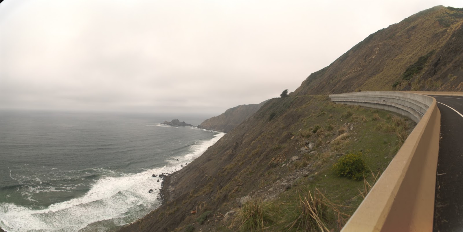
Any local of the San Francisco Bay Area knows about Devil's Slide. For years, HWY 1 ran through here, and the area had an sinister reputation of accidents and landslides that would close HWY1 and cut off Pacifica to the South (locals apparently dubbed themselves "the World's longest cul-de-sac"). However after the recent Caltrans project, the area has been sealed off from cars, and made into a hiking trail, though whether the area continues collapsing remains to be seen. It appears popular.


Mudstone, with stratification
Montara Mountain Granite
The Devil's Slide in California is a promontory with a steep, collapsing slope just South of Pacifica. Here, the Cretaceous granite of Montara Mountain  pushed against the Paleocene mudstone, a mix of marine shale, sandstone and conglomerate, of the San Mateo Coast.  Though the fault is now inactive, the mudstone has for decades been collapsing into the Pacific.


Devil's Slide
Due to its dangerous geology, Devi's Slide was undeveloped until 1907, when the Ocean Shore Railroad linked San Francisco to Half Moon Bay. The company quickly found the area difficult, as landslides required frequent maintenance, and finally stopped in 1921.  In 1937, HWY 1 opened here on the site of the old railroad, allowing drivers to move along most of the California coast.  Within days of opening, a landslide closed the road, and since then, landslide closures, became a frequent occurrence, including in 1942, 1951, 1952, 1977, 1982, and in 1983. In 1995,  a large side of the road collapsed, taking months of repair.  It occurred for the last time in 2006.

The periodic collapses of HWY1 at Devil's Slide provided a headache for Caltrans, the manager of the highway system.  In 1958, proposed a massive six-lane freeway going over Montara Mountain.  Complete with this would be a massive development of a corridor linking San Francisco to Half Moon Bay.  Caltrans waited for a disaster to allow Federal emergency funding to push through the plan. During this wait, locals, beginning to fight urban sprawl and appalled at the planned 200000 new residents in the area, and the destruction of wetlands for the endangered California Red-legged Frog, began forming local environmental movements. 

New Bridge passes over Shamrock Ranch
After local lobbying, in 1972, the California Coastal Commission put the 6-lane highway plan on hold.  Caltrans responded with a very large two-lane highway. The Sierra Club and other local groups then sued Caltrans based on the new National Environmental Policy Act. Though the groups were successful, Caltrans simply put the plan on hold, hoping to push it through during emergency repairs. After intense lobbying, Caltrans revised its plans, decreasing the new road, though it continued to run through critical watersheds and cut straight across a State Park. Another lawsuit in 1986 stopped the project.

Finally, in 1995 a tunnel plan was created, through Caltrans continued to state the freeway bypass was more cost-effective. After intense local outreach, and a leaked Caltrans document suggesting that the costs of the tunnel plan were purposefully inflated, the local community in 1996 passed Measure T by 74%, forcing Caltrans to utilize the tunnel approach.


Tom Lantos Tunnels

After Measure T passed, Caltrans changed its tune and began working on the tunnels. San Mateo Cong Tom Lantos had consistently pushed for Federal emergency funding to repair HWY1 at Devil's Slide, and with Sen Barbara Boxer helped secure Federal funding for this tunnel project.  In 2007 the boring began, which completed in 2013. The new tunnels, named after Congressman Tom Lantos, are 9m in diameter and 1265 m long Northbound (right) and 1222 m long Southbound (left), the second, and third longest tunnels in California.


The Devil's Slide Trail opened on March 27, 2014 as one of the newest trails in California.  It is 2km long and goes through Devil's Slide over two high but undulating hills.


San Pedro Rock is visible in the background
There are amazing views of the Pacific, of Devil's Slide itself, and of old military bases. Some interpretive signs are present.


Here, viewing the WWII-Era Fire Control Station which contains bunkers, pillboxes and a steel observation post,  the sheer instability of Devil's Slide is visible.


During WWII, Devil's Slide and Little Devil's Slide Military Reservations were set up, as at so many locations around the California coast, allowing visual triangulation of enemy ship and aircraft locations.  They have been abandoned since then.


Known locally as the Stairs, this forward fire control station would originally have been located firmly on cliffslide.  However heavy erosion around the bunker has now left it hanging tenuously alone. Sooner or later, it will collapse.


To reach Devil's Slide from San Francisco, Take HWY 1 to Pacifica.  After passing the Linda Mar District (with a Safeway and Denny's to the left), the road will begin to ascend.  Right before you come to a bridge, a small flashing light shows a pullout to a road on the right (the former HWY1).  Turn and park.  If you miss the turn (or find the parking lot is full), continue through the tunnels, and take the first right to another small parking lot, or just a little further, left to a large parking lot for McNee Ranch State Park.  The parking lots are often crowded and if you're unlucky you may need to park alongside HWY 1 and continue to the trail by walking along the curb.
https://www.google.com/maps/dir//37.5853267,-122.509998/@37.5789159,-122.5128304,15z/data=!4m3!4m2!1m0!1m0?hl=en